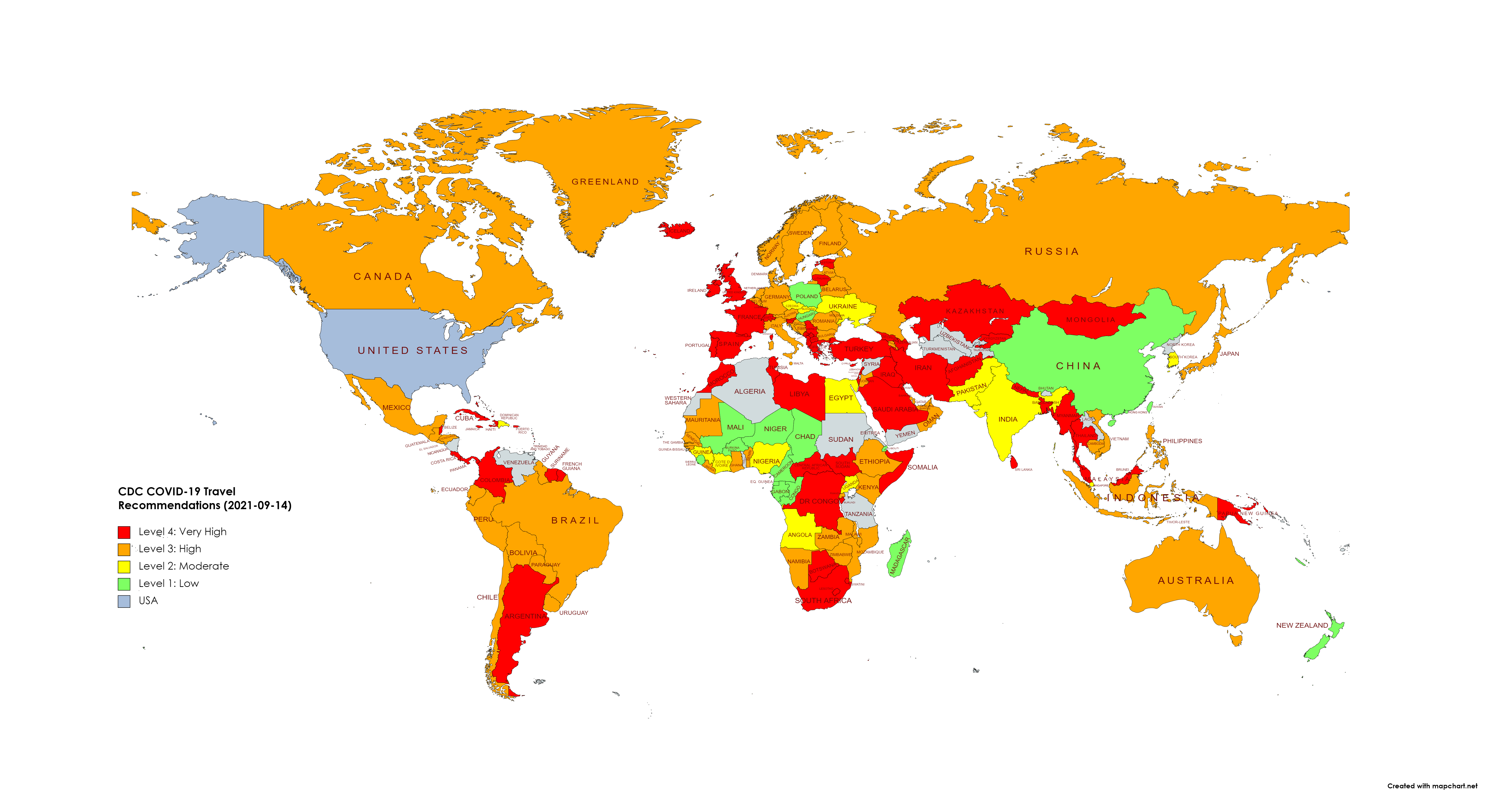
With the latest update to the CDC recommendations for international travel (trdr: don't), I wanted to visualize the stats of different countries. I found this neat little webapp that lets you interactively assign colors, export the data as JSON and then build a static PNG:
iamcal.com Since May 2000
Posts tagged maps
Simple world maps
Jan 5th: I created a couple of google maps helpers when I was working on personal projects a few years ago, but this tutorial on adding custom tooltips to overlay shapes was super useful.
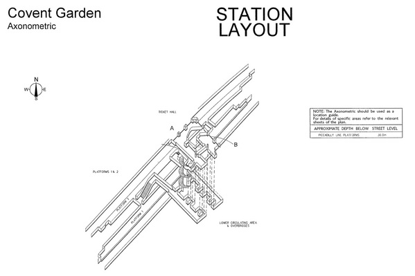
Axonometric Tube
Transport for London has released 124 axonometric diagrams of underground stations. Looking at stations you've walked through thousands of times is still a little confusing.
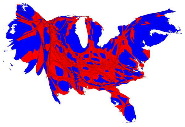
US Election Maps
Mark Newman at the University of Michigan has put together some nice visualizations of voting patterns in the 2012 US presidential elections, scaled by number of electoral college votes, rather than by land area.
Click and Drag
Today's xkcd combines my love of xkcd and slippy maps. And it's a big one. Luckily someone has put together a draggable/zoomable version.
More Underground Maps
Andrew Godwin has just released an excellent mapping project, visualizing a few London Underground stations, complete with public corridors, escalators, spiral staircases and platforms. The maps are 3D models, which you can pan and zoom inside the browser. Digging into the source is also worth a look, since it uses some nice canvas and three.js guts.
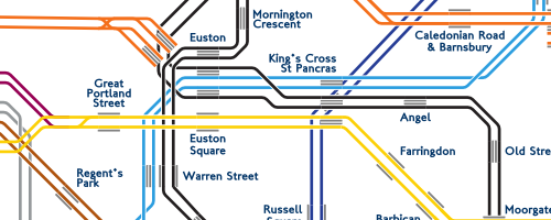
Poking around his other work, the Twin Tubes map is also worth a look - the underground network with each individual track visualized.
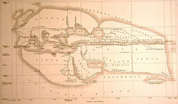
Early world maps
A fascinating look at early maps of the world. The relative scales vary wildly.
29th March, 4:14 pm
the process behind stamen's beautiful watercolor map tiles
21st March, 11:40 pm
these maps of sf, adjusted for sea levels rising, are very very awesome. luckily i live upstairs, just off the coast of point hayes
25th June, 10:48 pm
interested in transit mapping? then settle in and read this excellent paper
27th April, 11:26 am
i love this typographic map of sf. i have a few too many nice maps of SF to warrant hanging this one, but still considering it
15th October, 7:23 pm
the world according to san francisco is pretty accurate
16th June, 1:51 pm
the geography of lost blog have done an excellent hi-res map of the island. it's a big place (but still, why would you not walk the coast? really?)
28th February, 2:05 pm
very nice post on io9 about the various maps of lost island. a couple in there i hadn't seen before
3rd December, 1:02 pm
this interactive neighborhood map of nyc is very very well done
31st August, 11:22 pm
the folks at youcity are basically insane geniuses. with a focus on the insane part
2nd July, 10:16 am
this nyc subway ridership map is very very nice. great presentation
15th May, 12:49 pm
some really nice 3D city maps from norway. having that detail and the coverage of google maps would be great
11th May, 6:50 pm
these maps are super beautiful. are they just on show at the moment, or can you buy them?
4th May, 2:47 pm
S&W's horizonless maps of new york are lovely
10th November, 10:29 am
these election map visualizations are very nicely done. do you think the color-by-population was done by hand or with some fancy software?
17th July, 12:44 pm
reminded again of the plan for canada 2.0. it just makes sense
1st July, 12:26 pm
icaltrain has iphone-specific caltrain timetables. badass! they look great, too. caltrain has some other mobile versions too
19th March, 6:04 pm
maps based storytelling is very awesome [via pep]
19th July, 3:43 pm
looking back for this link i couldn;t find it, so here it is again. a version of the nyc subway map that makes for much easier reading.
6th July, 10:14 am
best google maps mashup ever [via hammond]
16th January, 10:38 am
i managed to miss this a year ago - i've had a village named after me
9th August, 10:41 pm
5th June, 12:52 pm
this tube map grid morph is pretty cool - now just need to tween to between that and the geo map for some nice dataporn. my zone one efforts are here (ff 1.5 only)
10th May, 3:12 pm
yahoo maps + ipod = ipod-directions [via dathan]
11th April, 7:12 pm
i thought i'd linked to cabspotting a while ago - maybe not.
3rd March, 2:24 pm
this geo news visualization has some nice ideas [via matts]
3rd March, 1:53 pm
salti found these excellent old maps and drawings of san francsico (and other places)
21st February, 3:52 pm
james wheare found an excellent hidden resource for the uk mapping crowd - a publically accessible database of all uk bus network geo locations (bus stops, etc) called NapTAN. seems like anyone can sign up and get the data. woo
20th February, 10:18 am
google maps meets world of warcraft? awesome
1st February, 11:09 pm
map24 is a nice java based mapping app [via george]
20th December, 7:17 pm
not sure if i linked to these yet - matt pointed me to this lovely piece of mapping work, showing the tube map based on time between stations.
14th November, 9:25 pm
omg. this is the best map visualization of public transport in the us i've ever seen. beautiful. via the cameron factor
3rd November, 10:28 pm
3rd November, 2:44 am
1st November, 9:25 pm
a nice link from the lul maps pages is this collection of maps including a couple of accurate line maps. niice.
1st November, 9:12 pm
some mapping stuff from matt jones - a list of london underground map resources (including a couple from me) and a map of the uk's motorways visualised in harry beck style. the latter would make a nice poster. time to break out the tabloid color laser at work i suspect.
20th October, 10:33 am
salty pointed me to the library that underlies the flash nyc subway map. looks pretty cool. would be better if you could somehow pass mouse events through to the browser. can't you send data in that direction from flash?
11th October, 8:10 pm
this nyc subway map is very very cool - google maps plus flash for some nice interactivity.
9th August, 11:33 am
this guide to embedding google maps in your opwn pages is great. well written and containing everything i wanted to know.
26th May, 2:50 pm
this is fucking awesome - a GPS linkup for google maps that follows the map as you move. fuck yeah
19th April, 9:33 am
google maps now includes the uk. although the entry url is different, it's the same app. you can scroll left to find america. no satellite photos yet, beyond the whole country. hope they get those online soon.
19th April, 9:23 am
angermann2 is my new favorite weblog. architecture, cartography and bold design.
8th April, 5:20 pm
george found this awesome app, which uses craigslist and google maps to produces an interactive map of apartments for rent. really fucking amazing. web services rule.
4th April, 8:22 pm
google maps was probably the best thing ever done on the internet - but now they've made it twice as good. fuuuuuck
11th March, 2:56 pm
it didn't take too long - aaron points out the first google maps-based app. firefox only (gah) but still fun. and vancouver-centric.
15th February, 11:32 am
aaron points out the investigation i would have done had i had the time - google maps would take about 8-11TB to store north america are pre-rendered GIFs. looks like it probably is all pre-pendered. but that's alot of gifs :)
8th February, 3:51 pm
it's been doing the rounds, but perhaps rightly so - a voting breakdown map of the uk.
7th February, 10:42 pm
the newly launched google maps is probably the best dhtml app ever. stunning.
About
This is the personal website of Cal Henderson, Slack co-founder & CTO.
I give occasional talks, write code and sometimes articles.
Recent Tags
aws books cheese code covid emoji fonts food games halflife havana ibm lego maps minecraft music php programming reading slack technology tube via-matts wiring
Popular Tags
apple awesome bacon code coding comics design flickr food games javascript lego maps movie music perl php programming software tech tv video visualization web
